![]()
![]()
![]()
e-shop kategórie
-
Nástenné mapy
- doplnky ku mapám
- stieracie mapy
- drevené mapy WOOD
- tapety
- svet
- kontinenty
- slovensko mapy
-
štáty
- Afganistan
- Albánsko
- Alžírsko
- Arménsko
- Austrália
- Azerbajdžan
- Bangladéš
- Belgicko
- Bhutan
- Bosna a Hercegovina
- Brazília
- Bulharsko
- Čierna Hora
- Česká republika
- Čína
- Dánsko
- Egypt
- Estónsko
- Filipíny
- Fínsko
- Francúzsko
- Grécko
- Gruzínsko
- Holandsko
- Chorvátsko
- India
- Indonézia
- Irak
- Irán
- Írsko
- Island
- Izrael
- Japonsko
- Jemen
- Jordánsko
- Kambodža
- Kanada
- Kazachstán
- Kórea
- Kosovo
- Kostarika
- Kuba
- Kyrgyzstán
- Libanon
- Litva
- Lotyšsko
- Luxembursko
- Lýbia
- Macedónia
- Maďarsko
- Malajzia
- Mauricius
- Mexiko
- Moldavsko
- Mongolsko
- Nemecko
- Nepál
- Nórsko
- Nový Zéland
- Omán
- Pakistan
- Poľsko
- Portugalsko
- Rakúsko
- Rumunsko
- Rusko
- Saudská Arábia
- Slovensko
- Slovinsko
- Spojené Arabské Emiráty
- Srbsko
- Sýria
- Španielsko
- Švédsko
- Švajčiarsko
- Tadžekistan
- Taliansko
- Thajsko
- Turecko
- Turkmenistan
- Ukrajina
- USA
- Uzbekistan
- Veľká Británia
- Vietnam
- Viac
- mestá
- špedičné a PSČ mapy
- politické mapy
- fyzické mapy
- panoramatické mapy
- reliéfne 3D mapy
- satelitné a ortofoto mapy
- historické mapy
- detské mapy
- vesmír
- Všetky podkategórie
- Glóbusy
-
Turistika
- Albánsko
- Argentína
- Bulharsko
- Čierna Hora
- Česká republika
- Dánsko
- Estónsko
- Francúzsko
- Grécko
- Gruzínsko
- Chile
- Chorvátsko
- India
- Írsko
- Južná Afrika
- Keňa
- Lesotho
- Litva
- Lotyšsko
- Maďarsko
- Maroko
- Nemecko
- Nepál
- Nórsko
- Portugalsko
- Rakúsko
- Rumunsko
- Rusko
- Slovensko
- Slovinsko
- Srbsko
- Svazijsko
- Španielsko
- Švajčiarsko
- Švédsko
- Taliansko
- Tanzánia
- Turecko
- Veľká Británia, Škótsko
- Uganda
- Ukrajina
- USA
- Všetky podkategórie
- Cykloturistika
- Atlasy
-
EURÓPA
- Albánsko
- Andorra
- Belgicko
- Bielorusko
- Bosna a Hercegovina
- Bulharsko
- Cyprus
- Česká republika
- Čierna Hora
- Dánsko
- Estónsko
- Fínsko
- Francúzsko
- Gibraltar
- Grécko
- Holandsko
- Chorvátsko
- Írsko
- Island
- Kosovo
- Lichtenštajnsko
- Litva
- Lotyšsko
- Luxembursko
- Macedónsko
- Maďarsko
- Malta
- Moldavsko
- Nemecko
- Nórsko
- Poľsko
- Portugalsko
- Rakúsko
- Rumunsko
- Rusko
- Slovensko
- Slovinsko
- Srbsko
- Španielsko
- Švajčiarsko
- Švédsko
- Taliansko
- Turecko
- Ukrajina
- Veľká Británia
- Všetky podkategórie
-
ÁZIA
- Ázia regióny
- Afganistan
- Arménsko
- Azerbajdžan
- Bahrajn
- Bangladéš
- Bhután
- Cyprus
- Čína
- Filipíny
- Gruzínsko
- India
- Indonézia
- Irak
- Irán
- Izrael
- Japonsko
- Jemen
- Jordánsko
- Kambodža
- Katar
- Kazachstan
- Kórea
- Kuvajt
- Kyrgyzstán
- Laos
- Libanon
- Malajzia
- Maledivy
- Mongolsko
- Myanmar
- Nepál
- Omán
- Pakistan
- Palestína
- Rusko
- Saudská Arábia
- Singapur
- Spojené arabské emiráty
- Srí Lanka
- Sýria
- Tadžekistan
- Taiwan
- Thajsko
- Tibet
- Turecko
- Turkmenistan
- Uzbekistan
- Vietnam
- Východný Timor
- Všetky podkategórie
-
AFRIKA
- Afrika regióny
- Alžírsko
- Angola
- Benin
- Botswana
- Burkina Faso
- Burundi
- Čad
- Džibutsko
- Egypt
- Eritrea
- Etiópia
- Gabon
- Gambia
- Ghana
- Guinea
- Guinea-Bissau
- Juhoafrická republika
- Kamerun
- Kapverdy
- Keňa
- Komory
- Kongo
- Lesotho
- Líbya
- Madagaskar
- Malawi
- Mali
- Maroko
- Mauretánia
- Mauricius
- Mozambik
- Namíbia
- Niger
- Nigéria
- Pobrežie Slonoviny
- Réunion
- Rwanda
- Sao Tome & Principe
- Senegal
- Seychely
- Sierra Leone
- Somálsko
- Stredoafrická republika
- Sudán
- Svazijsko
- Tanzánia
- Togo
- Tunisko
- Uganda
- Zambia
- Zimbabwe
- Všetky podkategórie
-
AMERIKA
- Amerika severná
- Amerika stredná a Karibik
- Amerika južná
- AUSTRÁLIA a PACIFIK
- ANTARKTÍDA a ZEMSKÉ PÓLY
- Zobraziť všetky
- Zobraziť viac
 |
|
____________________________________
POŠTOVNÉ vrámci ____________________________________ |
|
PREPRAVNÁ SPOLOČNOSŤ do 9,99 € ... 3,50 € nad 10,00 € ... 5,50 €
........................................................................... platba prevodom ..... 0,00 € platba platobnou bránou ..... 0,00 € platba dobierkou ..... 2,00 €
PACKETA výdajné miesto poštovné+balné ... 3,00 € LEN TOVAR dĺžka strany do 70cm ........................................................................... platba prevodom ..... 0,00 € platba platobnou bránou ..... 0,00 € platba dobierkou ..... 2,00 €
|
|
|
|
____________________________________
POŠTOVNÉ vrámci ____________________________________ |
|
PŘEPRAVNÍ SPOLEČNOST do 9,99 € .... 6,00 € nad 10,00 € ... 9,00 € ........................................................................... platba převodem ..... 0,00 € ........................................................................... PACKETA výdejní místa POUZE BALÍK délka strany do 70cm postovne+balné ... 5,20 € ........................................................................... platba převodem ..... 0,00 € platba dobírkou .... 2,00 € Důležité upozornění
Pro platbu v Kč objednávejte v eshopu www.worldmaps.cz. Bude Vám automaticky vystavena faktura v Kč, pro české firmy plátce dph v Kč bez dph.
Pro platbu v € objednávejte v eshopu www.worldmaps.sk. Stačí v košíku při dokončení objednávky zakliknout dodání vrámci EU. Bude Vám vystavena faktura v €, pro české firmy plátce dph v € bez dph.
Pokud jste již objednávku udělali v eshopu worldmaps.sk, a chcete platit v Kč, napište info do poznámky na konci objednávky, nebo pošlete email na info@worldmaps.sk. Zašleme Vám fakturu v Kč.
|
|
|
|
____________________________________
POSTAGE within ____________________________________ |
|
SHIPPING COMPANY up 9,99 € .... 6,00 € 10,00 € and more .... 9,00 € ........................................................................... payment by transfer .... 0,00 € ........................................................................... PACKETA Z-POINT ONLY package size up 70cm Z-POIT´s
delivery+packaging ... 5,20 € ........................................................................... payment by transfer ..... 0,00 € |


Úvod » Cykloturistika » Rakúsko » cyklosprievodcovia » Danube Bike Trail 2 - Astrian Danube cyklosprievodca Esterbauer / angl
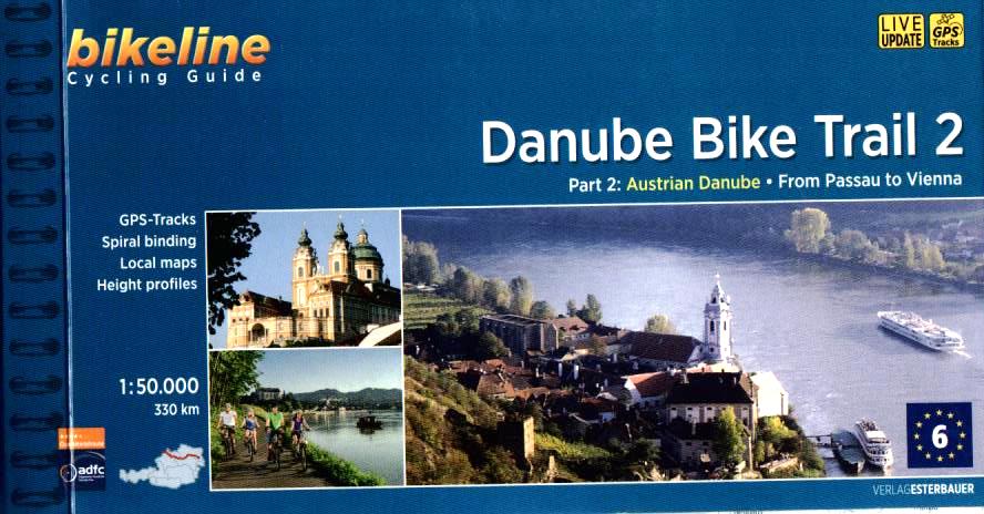
Danube Bike Trail 2 - Astrian Danube cyklosprievodca Esterbauer / angl

naskladníme po objednaní
Tweet
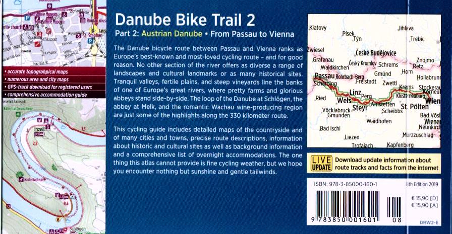
Part 2: Austrian Danube: From Passau to Vienna
Vaše hodnotenie:
Ďakujeme za Vaše hodnotenie
Ďakujeme za Vaše hodnotenie
0x
POPIS POLOŽKY
| typ: | cykloturistický sprievodca s mapami | ||
| jazyk: | anglický | ||
| vydavateľ: | Verlag Esterbauer GmbH | ||
| edícia: | Bikeline Cycling Guide | ||
| formát: | 23cm x 12cm | ||
| väzba: | špirálová | ||
| počet strán: | 160 strán | ||
| ISBN: | 9783850001601 | ||
| mierka: | 1 : 50.000 | ||
Bikeline Cycling Guide cykloturistický sprievodca DANUBE BIKE TRAIL 2 - Esterbauer
PART 2: Austrian Danube - From Passau to Vienna
- GPS-Tracks
- spiral bounding
- local maps
- height profiles
- distance 320 km
- 160 pages

Charakteristika cyklosprievodcu vydavateľom:
In the last decade the Danube bike trail has emerged as Europe’s most important long-distance bicycle touring route. Its popularity is due primarily to the Danube’s natural beauty and the wealth of cultural and historical sites that line its banks. But the large numbers of bicycle tourists visiting the Danube would not be possible without well-developed infrastructure and services. The Danube bike route has benefited from well-built posted bike trails and an extensive network of services oriented to meeting the needs of bicycle tourists. The following pages provide a few practical notes about how to use the book, and some tips on getting ready for the tour.
The Route
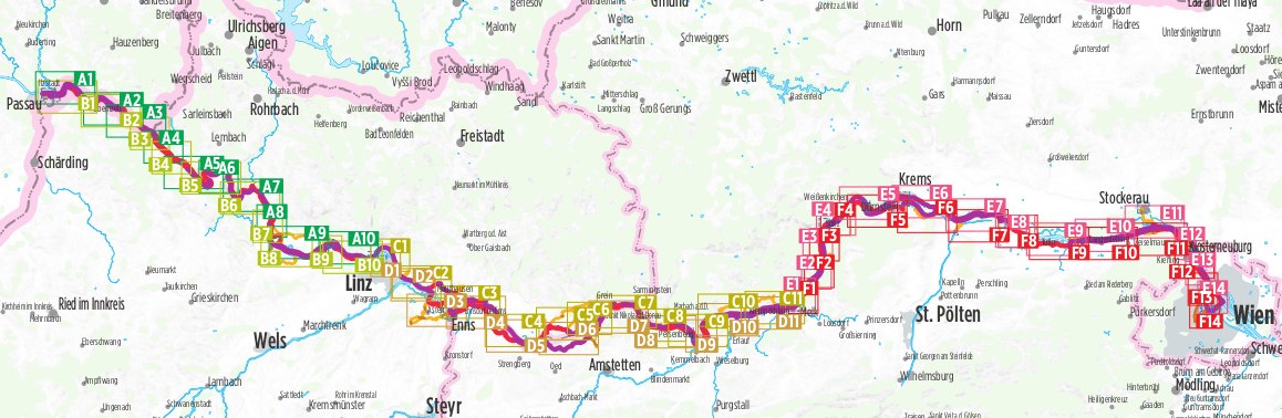
The Length
The total distance from the start in Passau to the final destination, Vienna, is 320 kilometres. This figure does not include about 160 kilometres of side-trips and alternative routes.
Surface quality and traffic
The Danube bicycle route is very comfortable to ride. Virtually the entire distance follows paved bicycle paths or lightly traveled public roads. For most of the distance, a bicycle route is present on both sides of the river.
ADFC classification
The Danube bike trail was given a 4-star classification by the ADFC in March 2012. The ADFC (General German Bicycle Club) inspects long-distance cycling routes and rates them on a 5-Star scale, assessing criteria such as route quality, safety and signage, as well as gastronomy, accommodation and access via public transport. The classification is valid for only 3 years.
Signage
The Danube bicycle route is thoroughly signposted to show the way. However, it does occasionally happen that signs are missing or turned in the wrong direction. In Austria, rectangular green signs are posted along the route and in most places the route is clearly labelled the “Donau-Radweg.” Other regional bicycle trails branch off from the main route. Excursions and alternative routes often follow their own signs, and are also described in this book.
Planning a tour
The descriptions of the 320 kilometer tour follow the river downstream, from west to east. This allows cyclists to take advantage of the prevailing winds and the river’s downward slope (minimal though it may be).
The Danube usually has bicycle routes on both sides of the river. All of these routes are marked as part of the Danube bicycle route. Keep in mind when planning your route, that the hills along much of the way cause the south bank to be generally shadier than the north bank during the spring and autumn months. This book describes the routes on both sides of the river: the route on the northern, or left bank is described first, followed by the route on the southern, or right bank. The entire tour is divided into three sections: Passau to Linz, Linz to Melk, and Melk to Vienna.
The two sides of the river are identified as the left and the right sides, as seen when looking downstream. To simplify orientation, towns and cities are given with their kilometer number on the Danube (ex. Passau ? 2226 or Vienna ? 1929) and the side of the river they occupy (L or R). The Danube’s kilometers are also shown in the maps (|1925). The division of the tour into six sections is intended to aid tourists’ general orientation and does not necessarily suggest one-day stages. If you intend to include museum visits and swimming stops along the way, we recommend planning at least a week for the entire distance. The book also includes descriptions of short side-trips which offer riders opportunities to extend the ride according to their desires.
If the tour turns out to take longer than expected, there are taxi companies along the first stage that will transport bicycles if the need arises. The telephone numbers of these companies are listed in the information about individual towns. Rail lines also run along much of the Danube, giving riders the option of boarding a train to complete a stretch.